Ongoing plans: Commemorating all things Netherby.
The goal with this page is to promote ideas people have regarding ways to continue commemorating the Netherby Shipwreck.
At present folks are considering:
- a memorial at Point Roadknight commemorating the bravery of John Parry. Glenn Pinnuck is keen to assist with this project.
- a memorial seat and wall at Netherby Cove on King Island - including plaques featuring passengers names and a way to show visitors the exact location of the wreck. Ann Rutte is very passionate about this one.
- a get together on King Island for the 160th anniversary, including checking the contents of the sea chest time capsule entrusted into the care of the King Island Museum on 17 July 2016.
As webmistress - my ongoing goals are:
- to build the most concise and correct passenger and crew list as humanly possible
- to establish exactly who went to QLD and who stayed in VIC. (Commenced on a new page "Onward to Brisbane, or stayed in Melbourne" 15 Aug 2017). 2018: This is mostly now confirmed via the City of Melbourne passenger list here.
- to continue collecting information from everyone out there to create a passenger history page for your ancestors who were on the ship.
- I would love to start a collection/database of photos of passengers graves/headstones and locations.
- Find the location of the ships anchor. May need to get Hobart Maritime Museum involved.
- I noticed that the Dept of Environment website has a page on the Netherby and it contains quite a few furphies so I have diarised to contact them to correct it.
- Other item on my "to do" list is to research how to get my website back into Google search results as it has fallen out of them since Ai has taken over Google Search. It is quite detrimental to my sites and those of so many other people around the world. Everyone's hard work is just disappearing while the content itself will be scraped and used by Google as if it has done all the research itself.
Head to our Facebook Page or the Discussion Forum (links in the Social Media page on the left) to leave any ideas you want to add here.
October 2019: I (Karina) have been scrolling through Google images looking for idea for a memorial seat and wall that could be located at Netherby Cove facing the wreck site, for people to sit and reflect. If anyone else has ideas please feel free to contribute via the Facebook group and I will add them here.
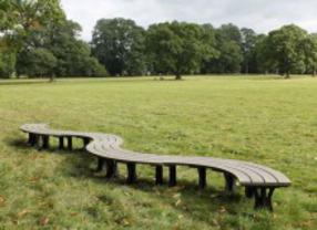
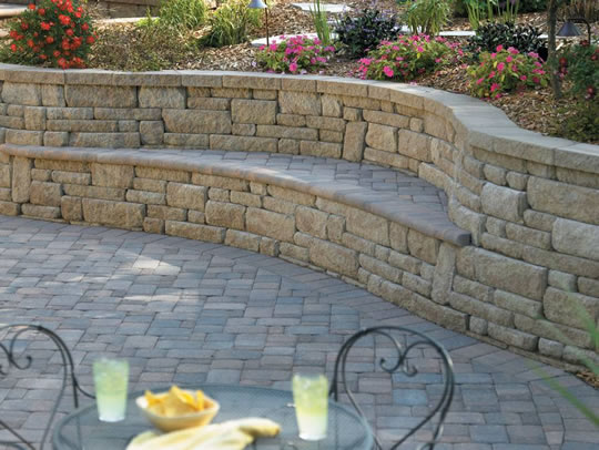
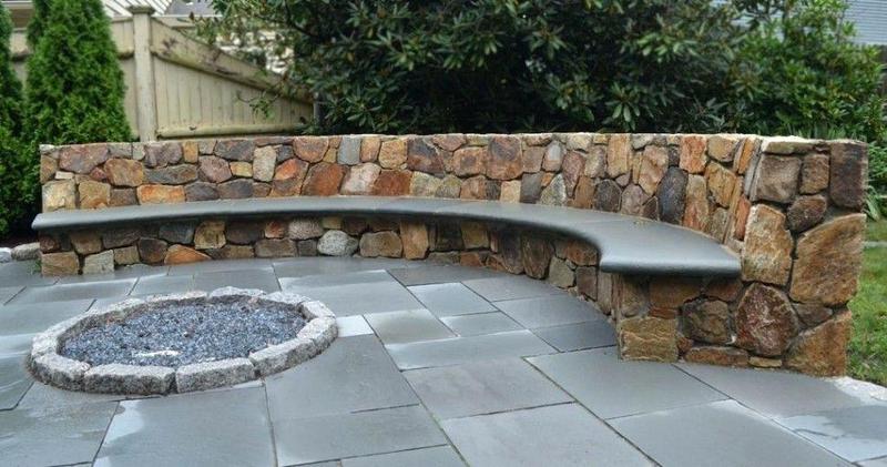
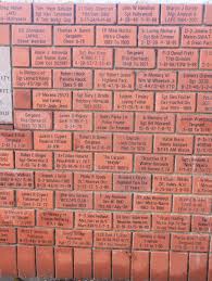
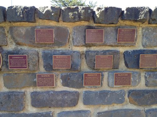
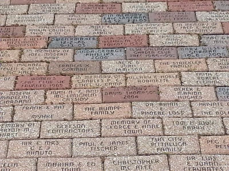
I picture a long curved bench like this (image left) but built into a low curved brick wall like the images middle and right. The bricks themselves would have dedications to the passengers, contributed by descendants, either imprinted direct into the bricks in below images left and middle, or with plaques in the image below right. Pavers on the ground could also have dedications if there are too many for the front and back of the wall.
The cost of initial construction could be via a fundraiser through descendants and help from King Island Lion's Club and locals for the actual build. Descendants would then 'buy a brick' or 'buy a plaque' to have their dedication added to the wall/ground.
July 2020: Pondering further based on some idea's Ann Rutte was having about how to show from the shore the position where the wreck is.
What about - on top of the curved brick wall described above, we have a plaque that tells the brief story, a map of the journey, and sticking up from the plaque, a see through metal cutout outline of a ship - that when someone bends down and looks through it - it is positioned approximately where the wreck is.
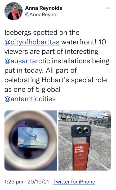
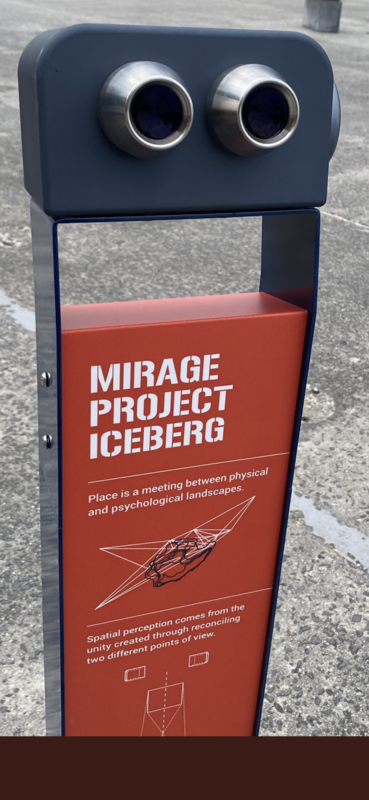
Oct 2022: I found this idea on Twitter a while ago and wondered if it might fit Ann's idea. It is essentially a mirage viewer - when you look through it it displays a mirage of something. In this case it was icebergs in Hobart harbour. But could it be done to show a ship out on the reef ?
July 2020: Memorial to John Parry.
Ann and Karina had been spending some time in the Victorian Archives centre digging our way through boxes and boxes of records in an effort to pinpoint the exact (or closest) location that Parry and the others came ashore in the longboat, with a view to having a memorial placed there. This was a dream of shipwreck historian, the late Don Charlwood.
I am also wondering whether consideration could be given to placing a similar plaque on Parry's grave. Its location is here: https://www.findagrave.com/memorial/201152577/john-billington_hayes-parry
Ill health and then Covid restrictions have brought that on site research to a halt for now but I definitely plan to continue it when possible.
I would like the plaque/s to spell out his achievements in saving the passengers in a visual way. I can picture a map showing King Island, Bass Strait and the lower half of Vic. A dotted line would mark out the entire path he took (per my below notes) with big numbered/lettered dots at specified points. Beside the map a legend would show the dot numbers/letters and the points below including the dates and km. I think this would demonstrate what an exhausting and heroic feat it actually was.
3 day walk to lighthouse, long boat journey across Bass Strait to the landing point (Point Roadknight below the Barwon Heads ... there is conjecture and misreporting as to the exact landing location which Loutit Bay also referenced in the papers, the closest assumption is that it was near what is now the town of Anglesea on the Great Ocean Road).
Parry then set off on borrowed horse to ride to Queenscliffe (approx. 65 km) (The Age 23 July 1866) reaching there on Saturday evening to telegraph word of the wreck to the Williamstown Harbour Master Captain Charles Ferguson, then rode to Geelong (a further 35 km) to catch a train to Melbourne.
Parry then immediately boarded the steam ship Victoria on the Sunday at 11am to assist in the navigation back to the wreck site to rescue the passengers. he remained on the island apparently to collect salvage. A plaque on King Island states he was there for 6 days from 2 August 1866, however shipping notices state he returned to Melbourne on the salvage cutter Ben Bolt on 1 Sept 1866.
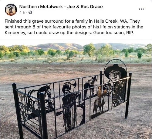
Oct 2022: Memorial to John Parry.
I have had this in my folders for a couple of years and just remembered to add it here so I don't lose it. A WA friend follows these metal workers on Facebook and shared this with me as a possible idea for a grave surround for Parry. Could be less elaborate (maybe just a top and bottom end) but definitely include his image, a map of his rescue route and a story.
Their work can be quite detailed based on the photos on their Facebook page.

November 2024: Came across this photo on Threads showing an information sign at a ruined castle in Donzon Kula Serbia. I thought it might be a great way to achieve Ann's vision of people being able to "see" the wreck while standing at Netherby Cove. I sent her this image and we shared some ideas.
- could it be on top of the planned memorial wall so you stand on one side of the wall facing the sea and see the wreck as it would have looked on the reef.
- would it be a picture of the wreck or a picture pre wreck.
- could it be two images ie in the top corner the ship pre wreck, with the dates and maybe the route map, then the main image being the wreck lining up with the now visible reef.